
Make a donation
Catanzaro topographic map
Click on the map to display elevation.
Make a donation
Catanzaro
Catanzaro overlooks the Gulf of Squillace, in the Ionian Sea. The district of Catanzaro stretches from the sea to an elevation of 600 metres (2,000 ft). The historic center is approximately 300 metres (980 ft) above sea level. The town dates back to the valley of Fiumarella (formerly known as River Zaro). The Bishopric, St. Tryphon (or San Rocco) and St. John (or castle) marks the city's historical centre and is connected to the North Sila. Due to its particular geography, the municipality gets wet from the sea and is still subjected to a snowy winter. Catanzaro's rivers include the mainstream of the Fiumarella (in local dialect Hjiumareddha), which joins with the river Musofalo, and the torrent Corach (formerly called Crotalo).
Make a donation
About this map
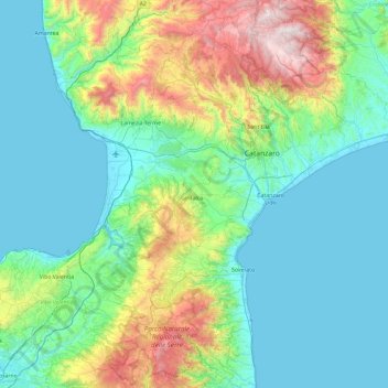
Name: Catanzaro topographic map, elevation, terrain.
Location: Catanzaro, Calabria, Italy (38.46334 16.09571 39.19424 16.92060)
Average elevation: 353 m
Minimum elevation: -1 m
Maximum elevation: 1,756 m
Make a donation
Other topographic maps
Click on a map to view its topography, its elevation and its terrain.
Make a donation
Make a donation
Make a donation
Trenta
Trenta is a town high in the Crati river Valley. The town's ancient name, Triginta, derives from the Latin number triginta or thirty. Trenta was founded by Cosentine refugees in the 10th century AD, in the era of Saracen occupations of the nearby capital, Magli, which eventually became one of the…
Average elevation: 560 m
Make a donation
Make a donation