
Thank you for supporting this site ❤️
Make a donation
Make a donation
Alt-Hoeselt topographic map
Click on the map to display elevation.
Thank you for supporting this site ❤️
Make a donation
Make a donation
Alt-Hoeselt
Het plateau, met een hoogte tot 100 meter, wordt benut voor landbouw en fruitteelt.
Thank you for supporting this site ❤️
Make a donation
Make a donation
About this map
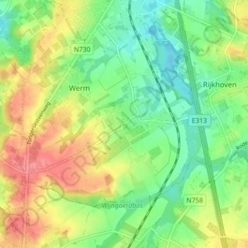
Name: Alt-Hoeselt topographic map, elevation, terrain.
Average elevation: 85 m
Minimum elevation: 55 m
Maximum elevation: 124 m
Thank you for supporting this site ❤️
Make a donation
Make a donation
Other topographic maps
Click on a map to view its topography, its elevation and its terrain.
Sint-Huibrechts-Hern
België > Limburg > Tongeren > Hoeselt
Sint-Huibrechts-Hern is gelegen in vochtig-Haspengouw. Ten oosten van de kom ligt een bosachtig gebied. De hoogte varieert van 70 tot 112 meter. Zie verder onder Vrijhern.
Average elevation: 91 m