
La Malterre topographic map
Interactive map
Click on the map to display elevation.
About this map
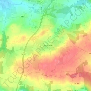
Name: La Malterre topographic map, elevation, terrain.
Average elevation: 87 m
Minimum elevation: 44 m
Maximum elevation: 125 m
Other topographic maps
Click on a map to view its topography, its elevation and its terrain.
La Ménagerais
France > Bretagne > Ille-et-Vilaine > Guignen
La Ménagerais, Guignen, Redon, Ille-et-Vilaine, Bretagne, France métropolitaine, 35580, France
Average elevation: 68 m
Le Plessis Thuaux
France > Bretagne > Ille-et-Vilaine > Guignen
Le Plessis Thuaux, Guignen, Redon, Ille-et-Vilaine, Bretagne, France métropolitaine, 35580, France
Average elevation: 70 m