
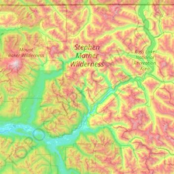
North Cascades National Park topographic map
Interactive map
Click on the map to display elevation.
About this map
Name: North Cascades National Park topographic map, elevation, terrain.
Average elevation: 1,151 m
Minimum elevation: 32 m
Maximum elevation: 3,265 m
Other topographic maps
Click on a map to view its topography, its elevation and its terrain.
Montesano
USA > Washington > Montesano
Montesano, Grays Harbor County, Washington, USA
Average elevation: 65 m
Scimitar Glacier
Scimitar Glacier, Pacific Crest Trail, Snohomish County, Washington, USA
Average elevation: 2,270 m
Spire Glacier
Spire Glacier, Ptarmigan Traverse, Chelan County, Washington, USA
Average elevation: 1,946 m
Hinman Glacier
Hinman Glacier, Necklace Valley Trail, King County, Washington, USA
Average elevation: 1,858 m
Entiat Glacier
Entiat Glacier, Mount Maude Summit Approach, Chelan County, Washington, USA
Average elevation: 2,145 m
Mary Green Glacier
USA > Washington > Holden Village
Mary Green Glacier, Cloudy Pass Trail #1256, Holden Village, Chelan County, Washington, USA
Average elevation: 2,140 m
Stuart Glacier
Stuart Glacier, Horseshoe Lake Trail, Chelan County, Washington, USA
Average elevation: 2,098 m
Cowlitz Glacier
USA > Washington > Paradise
Cowlitz Glacier, Camp Muir Route, Paradise, Pierce County, Washington, USA
Average elevation: 2,371 m
Edmunds Glacier
Edmunds Glacier, Pierce County, Washington, USA
Average elevation: 2,619 m
Buckner Glacier
Buckner Glacier, Thunder Creek Trail, Skagit County, Washington, USA
Average elevation: 2,094 m
Unicorn Glacier
Unicorn Glacier, Bench and Snow Lake Trail, Lewis County, Washington, USA
Average elevation: 1,636 m
Banded Glacier
Banded Glacier, Fisher Creek Trail, Skagit County, Washington, USA
Average elevation: 2,158 m
Kautz Glacier
USA > Washington > Paradise
Kautz Glacier, Van Trump Trail, Paradise, Pierce County, Washington, USA
Average elevation: 2,726 m
Middle Cascade Glacier
Middle Cascade Glacier, Ptarmigan Traverse, Chelan County, Washington, USA
Average elevation: 1,981 m
Fairchild Glacier
Fairchild Glacier, Mount Carrie Way Trail, Clallam County, Washington, USA
Average elevation: 1,611 m
White Glacier
White Glacier, Jefferson County, Washington, USA
Average elevation: 1,739 m
White Salmon Glacier
White Salmon Glacier, Fisher Chimneys, Whatcom County, Washington, USA
Average elevation: 1,691 m
Humes Glacier
Humes Glacier, Humes Glacier Route, Jefferson County, Washington, USA
Average elevation: 1,613 m
Mount Saint Helens
Mount Saint Helens, Skamania County, Washington, USA
Average elevation: 2,108 m
McAllister Glacier
McAllister Glacier, Roush basin access trail, Skagit County, Washington, USA
Average elevation: 2,041 m
Richardson Glacier
Richardson Glacier, Chelan County, Washington, USA
Average elevation: 2,109 m
Mazama Glacier
Mazama Glacier, South Climb Trail #183, Yakima County, Washington, USA
Average elevation: 2,568 m
Shoestring Glacier
Shoestring Glacier, Worm Flows Climbing Route, Skamania County, Washington, USA
Average elevation: 1,945 m
Mount Rainier
Mount Rainier, Pierce County, Washington, USA
Average elevation: 3,938 m
Mount Shuksan
Mount Shuksan, Whatcom County, Washington, USA
Average elevation: 2,126 m
Paradise Glacier
USA > Washington > Paradise
Paradise Glacier, Camp Muir Route, Paradise, Pierce County, Washington, USA
Average elevation: 2,256 m
South Cascade Glacier
South Cascade Glacier, Ptarmigan Traverse, Chelan County, Washington, USA
Average elevation: 1,972 m
North Mowich Glacier
North Mowich Glacier, Spray Park Trail, Pierce County, Washington, USA
Average elevation: 2,483 m
Goode Glacier
Goode Glacier, North Fork Bridge Creek, Chelan County, Washington, USA
Average elevation: 1,877 m
Isella Glacier
USA > Washington > Holden Village
Isella Glacier, Cloudy Pass Trail #1256, Holden Village, Chelan County, Washington, USA
Average elevation: 2,258 m
Flett Glacier
Flett Glacier, Spray Park Trail, Pierce County, Washington, USA
Average elevation: 2,185 m
Lyman Glacier
Lyman Glacier, Highline Trail, Yakima County, Washington, USA
Average elevation: 2,722 m
So-Bahli-Alhi Glacier
USA > Washington > White Horse
So-Bahli-Alhi Glacier, Neiderprum Trail, White Horse, Snohomish County, Washington, USA
Average elevation: 1,382 m
Klickitat Glacier
Klickitat Glacier, South Climb Trail #183, Yakima County, Washington, USA
Average elevation: 2,434 m
Van Trump Glacier
USA > Washington > Paradise
Van Trump Glacier, Van Trump Trail, Paradise, Pierce County, Washington, USA
Average elevation: 2,389 m
Challenger Glacier
Challenger Glacier, Little Beaver Trail, Whatcom County, Washington, USA
Average elevation: 1,924 m
Sherpa Glacier
Sherpa Glacier, Horseshoe Lake Trail, Chelan County, Washington, USA
Average elevation: 2,069 m
Fryingpan Glacier
Fryingpan Glacier, Wonderland Trail, Pierce County, Washington, USA
Average elevation: 2,386 m
Lyall Glacier
Lyall Glacier, Maple Pass Trail, Chelan County, Washington, USA
Average elevation: 1,932 m
Davenport Glacier
Davenport Glacier, Sahale Arm Trail, Skagit County, Washington, USA
Average elevation: 2,143 m
Henry M. Jackson Wilderness
Henry M. Jackson Wilderness, Cady Creek Trail, Chelan County, Washington, USA
Average elevation: 1,307 m
Thunder Glacier
Thunder Glacier, Thunder Creek Trail, Skagit County, Washington, USA
Average elevation: 1,948 m
Sulphide Glacier
Sulphide Glacier, Sulfide Glacier Route, Whatcom County, Washington, USA
Average elevation: 1,815 m
Yawning Glacier
Yawning Glacier, Ptarmigan Traverse, Chelan County, Washington, USA
Average elevation: 1,712 m
Ermine Glacier
Ermine Glacier, Pacific Crest Trail, Snohomish County, Washington, USA
Average elevation: 2,233 m
Kimtah Glacier
Kimtah Glacier, Fisher Creek Trail, Skagit County, Washington, USA
Average elevation: 1,996 m
Hubert Glacier
Hubert Glacier, Blue Glacier Primitive Trail, Jefferson County, Washington, USA
Average elevation: 1,802 m