
Thank you for supporting this site ❤️
Make a donation
Make a donation
Huldenberg topographic map
Click on the map to display elevation.
Thank you for supporting this site ❤️
Make a donation
Make a donation
About this map
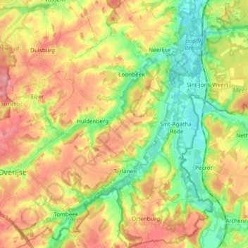
Name: Huldenberg topographic map, elevation, terrain.
Location: Huldenberg, Louvain, Brabant flamand, 3040, Belgique (50.74103 4.55514 50.83512 4.65540)
Average elevation: 68 m
Minimum elevation: 21 m
Maximum elevation: 119 m
Thank you for supporting this site ❤️
Make a donation
Make a donation
Other topographic maps
Click on a map to view its topography, its elevation and its terrain.
Moorsel
Belgique > Brabant flamand > Louvain > Tervuren
Ce village, entouré de Vossem, Sterrebeek, Kortenberg, Leefdaal et Tervuren, est situé sur le plateau brabançon ondoyant entre 85 et 90 m d'altitude. Ce hameau résidentiel combine à la fois un caractère rural et périurbain ce qui se caractérise par une alternance de champs, de villas et de vieilles…
Average elevation: 75 m
Thank you for supporting this site ❤️
Make a donation
Make a donation