
Timlouka topographic map
Interactive map
Click on the map to display elevation.
About this map
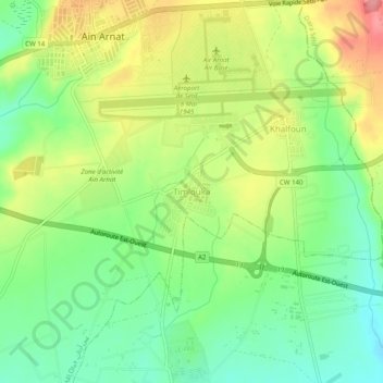
Name: Timlouka topographic map, elevation, terrain.
Location: Timlouka, Aïn Arnat, Daïra Aïn Arnat, Sétif, 19017, Algérie (36.14870 5.30598 36.18870 5.34598)
Average elevation: 999 m
Minimum elevation: 956 m
Maximum elevation: 1,058 m
Other topographic maps
Click on a map to view its topography, its elevation and its terrain.
Mehdia
Algérie > Sétif > Daïra Aïn Arnat > Aïn Arnat
Mehdia, Aïn Arnat, Daïra Aïn Arnat, Sétif, Algérie
Average elevation: 973 m