
Thank you for supporting this site ❤️
Make a donation
Make a donation
Crystal Lawns topographic map
Click on the map to display elevation.
Thank you for supporting this site ❤️
Make a donation
Make a donation
About this map
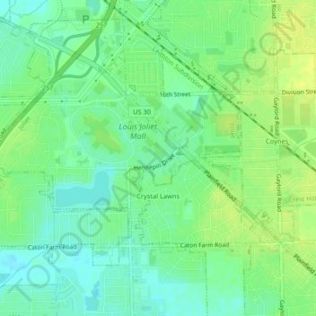
Name: Crystal Lawns topographic map, elevation, terrain.
Location: Crystal Lawns, Will County, Illinois, United States (41.56540 -88.18121 41.58239 -88.14065)
Average elevation: 187 m
Minimum elevation: 178 m
Maximum elevation: 196 m
Thank you for supporting this site ❤️
Make a donation
Make a donation
Other topographic maps
Click on a map to view its topography, its elevation and its terrain.