
Thank you for supporting this site ❤️
Make a donation
Make a donation
Barmstedt topographic map
Click on the map to display elevation.
Thank you for supporting this site ❤️
Make a donation
Make a donation
Barmstedt
Der Name wurde erstmals 1140 als Barmiste verschriftlicht. 1212 ist Barmetstede geschrieben worden und ein Schriftzeugnis von 1221 lautet Barmestide. Es liegen niederdeutsch barm und -stedt zugrunde. Die Bedeutung ist ‚Siedlung an der Anhöhe‘.
Thank you for supporting this site ❤️
Make a donation
Make a donation
About this map
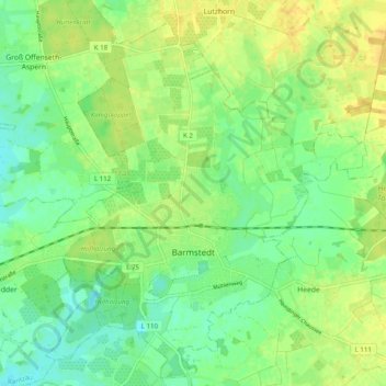
Name: Barmstedt topographic map, elevation, terrain.
Average elevation: 15 m
Minimum elevation: 3 m
Maximum elevation: 27 m
Thank you for supporting this site ❤️
Make a donation
Make a donation
Other topographic maps
Click on a map to view its topography, its elevation and its terrain.
Tävsmoor/Haselauer Moor
Deutschland > Schleswig-Holstein > Kreis Pinneberg > Appen
Average elevation: 9 m
Thank you for supporting this site ❤️
Make a donation
Make a donation
Liether Kalkgrube
Deutschland > Schleswig-Holstein > Kreis Pinneberg > Klein Nordende
Average elevation: 14 m