
当涂县 topographic map
Interactive map
Click on the map to display elevation.
About this map
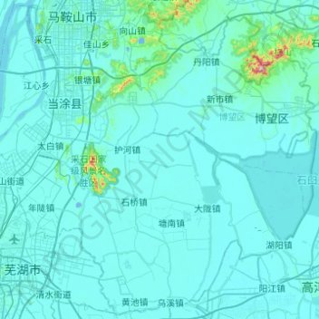
Name: 当涂县 topographic map, elevation, terrain.
Location: 当涂县, 马鞍山市, 安徽省, 243100, 中国 (31.29207 118.37118 31.69995 118.86374)
Average elevation: 18 m
Minimum elevation: -6 m
Maximum elevation: 437 m
当涂境内以平原为主,有冲积、湖积平原,海拔在10~20米以下,地势坦荡,由粘质砂土、砂质粘土等组成。分布于境北部丘陵、低山区与平原的过渡地带,受轻度抬升影响,原系河流、湖泊阶地,再被抬升,并经流水切割,形成地势高亢、起伏不平的台地。除外,境内还有低山、丘陵,海拔最高的不超过500米。
Other topographic maps
Click on a map to view its topography, its elevation and its terrain.