
Thank you for supporting this site ❤️
Make a donation
Make a donation
Les Escaldes topographic map
Click on the map to display elevation.
Thank you for supporting this site ❤️
Make a donation
Make a donation
About this map
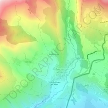
Name: Les Escaldes topographic map, elevation, terrain.
Average elevation: 1,491 m
Minimum elevation: 1,211 m
Maximum elevation: 1,977 m
Thank you for supporting this site ❤️
Make a donation
Make a donation
Other topographic maps
Click on a map to view its topography, its elevation and its terrain.
Lac des Bouillouses
France > Occitania > Pyrénées-Orientales > Angoustrine-Villeneuve-des-Escaldes
Lac des Bouillouses or Llac de la Bollosa is a lake in Pyrénées-Orientales, France. At an elevation of 2017 m, its surface area is 1.49 km².
Average elevation: 2,091 m