
Make a donation
Rayong Province topographic map
Click on the map to display elevation.
Make a donation
About this map
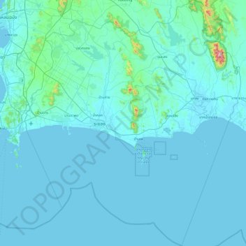
Name: Rayong Province topographic map, elevation, terrain.
Location: Rayong Province, Thailand (12.21597 100.98445 13.16356 101.83105)
Average elevation: 39 m
Minimum elevation: -1 m
Maximum elevation: 973 m
Make a donation
Other topographic maps
Click on a map to view its topography, its elevation and its terrain.
Khon Kaen
Khon Kaen is on the Khorat Plateau, elevation 187 m, and is the center of the mid-northeastern provincial group of Thailand, according to the Thai government. Its coordinates are 16°26′N 102°50′E / 16.433°N 102.833°E / 16.433; 102.833. The city municipality has a population of 114,459, while…
Average elevation: 165 m
Make a donation
Make a donation
Make a donation
Make a donation
Make a donation
Make a donation
Make a donation
Make a donation
Make a donation
Phu Kradung
Thailand > Phu Kradueng District
Phu Kradueng National Park (Thai: อุทยานแห่งชาติภูกระดึง), in the Si Than sub-district of Amphoe Phu Kradueng, Loei Province, is a national park in Thailand. It has a high point of 1,316 m (4318 ft) elevation at Khok Moei. It was proclaimed a national park on 23…
Average elevation: 1,183 m
Make a donation
Make a donation
Make a donation
Make a donation
Make a donation
Make a donation
Make a donation
Make a donation
Prachuap Khiri Khan
Thailand > Mueang Prachuap Khiri Khan
Prachuap Khiri Khan covers an area totaling 6,367 square kilometers (2,458 sq mi). The province is on the Kra Isthmus, the narrow land bridge connecting the Malay Peninsula with mainland Asia. The province has one of the narrowest parts of Thailand, just 12.38 km (7.69 mi) from the Gulf of Thailand to the…
Average elevation: 9 m
Make a donation
Doi Inthanon
In 1954, the forests around Doi Inthanon were conserved, creating Doi Inthanon National Park, as one of the original 14 national parks of Thailand. This park now covers 482.4 km2 and spreads from the lowlands at 800 metres (2,625 ft) elevation up to the peak at 2,565 metres (8,415 ft). Given the varied…
Average elevation: 2,364 m
Mae Salong
Thailand > Mae Fa Luang > Mae Fa Luang district
Mae Salong is a hilltop village in the Mae Fa Luang district of Thailand's Chiang Rai Province, about 80 kilometres (50 mi) from Chiang Rai. Mae Salong is on the highest peak of the Doi Mae Salong range of mountains, at an elevation of 1,134 metres (3,722 ft) above sea level. It has an alpine-like climate,…
Average elevation: 1,035 m
Make a donation
Make a donation
Make a donation
Make a donation
Make a donation
Mae Haad Cove (Nudist Beach)
Thailand > Ko Pha-ngan District > Baan Wang Ta Kien > Haad Mae Haad
Average elevation: 42 m
Make a donation
Make a donation