
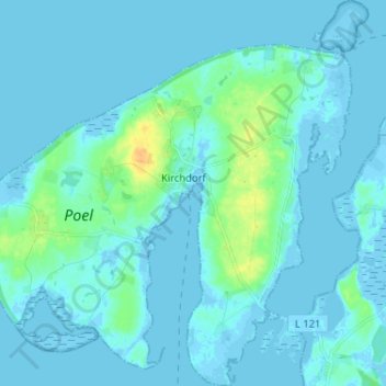
Insel Poel topographic map
Interactive map
Click on the map to display elevation.
About this map
Name: Insel Poel topographic map, elevation, terrain.
Average elevation: 3 m
Minimum elevation: -4 m
Maximum elevation: 27 m
Other topographic maps
Click on a map to view its topography, its elevation and its terrain.
Poel
Germany > Mecklenburg-Vorpommern > Nordwestmecklenburg > Kirchdorf
Poel, Kirchdorf, Insel Poel, Nordwestmecklenburg, Mecklenburg-Vorpommern, 23999, Germany
Average elevation: 3 m
Lünenberg
Germany > Mecklenburg-Vorpommern > Nordwestmecklenburg > Passee
Lünenberg, Passee, Neukloster-Warin, Nordwestmecklenburg, Mecklenburg-Vorpommern, Germany
Average elevation: 89 m
Greese
Germany > Mecklenburg-Vorpommern > Nordwestmecklenburg > Lübow
Greese, Lübow, Dorf Mecklenburg-Bad Kleinen, Nordwestmecklenburg, Mecklenburg-Vorpommern, Germany
Average elevation: 25 m