
Make a donation
Masontown topographic map
Click on the map to display elevation.
Make a donation
About this map
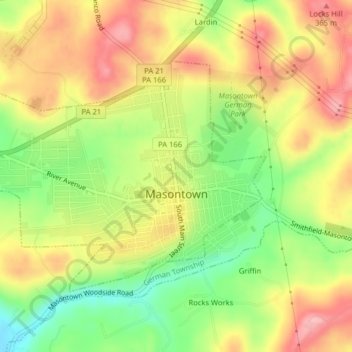
Name: Masontown topographic map, elevation, terrain.
Average elevation: 308 m
Minimum elevation: 236 m
Maximum elevation: 372 m
Make a donation
Other topographic maps
Click on a map to view its topography, its elevation and its terrain.
South Uniontown
United States > Pennsylvania > Fayette County > South Union Township
Average elevation: 337 m
New Meadow Run Bruderhof
United States > Pennsylvania > Fayette County > Wharton Township
Average elevation: 583 m
West Leisenring
United States > Pennsylvania > Fayette County > Dunbar Township
Average elevation: 335 m
Make a donation
Mount Braddock
United States > Pennsylvania > Fayette County > North Union Township
Average elevation: 397 m
Merrittstown
United States > Pennsylvania > Fayette County > Redstone Township
Average elevation: 318 m
Make a donation
McClellandtown
United States > Pennsylvania > Fayette County > German Township
Average elevation: 338 m
Lake Lynn
United States > Pennsylvania > Fayette County > Springhill Township
Average elevation: 324 m
Make a donation
La Belle
United States > Pennsylvania > Fayette County > Luzerne Township > Luzerne
Average elevation: 296 m
Keisterville
United States > Pennsylvania > Fayette County > Menallen Township
Average elevation: 347 m
Indian Head
United States > Pennsylvania > Fayette County > Saltlick Township
Average elevation: 512 m
Make a donation
East Millsboro
United States > Pennsylvania > Fayette County > Luzerne Township
Average elevation: 310 m
Make a donation
Lemont Furnace
United States > Pennsylvania > Fayette County > North Union Township
Average elevation: 372 m
Make a donation
Grindstone
United States > Pennsylvania > Fayette County > Jefferson Township
Average elevation: 313 m
Make a donation
Trotter
United States > Pennsylvania > Fayette County > Dunbar Township > Trotter
Average elevation: 322 m
Tower Hill Number Two
United States > Pennsylvania > Fayette County > Luzerne Township > Tower Hill Number Two
Average elevation: 325 m
Jumonville
United States > Pennsylvania > Fayette County > North Union Township > Jumonville
Average elevation: 613 m
Make a donation
Mill Run
United States > Pennsylvania > Fayette County > Springfield Township
Average elevation: 482 m
Buena Vista
United States > Pennsylvania > Fayette County > Franklin Township
Average elevation: 384 m
Make a donation