
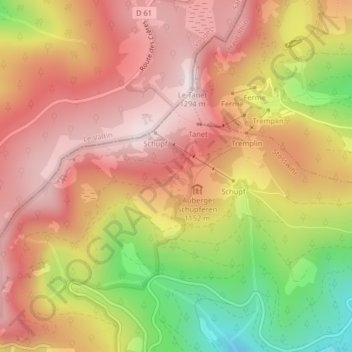
Fontaine topographic map
Interactive map
Click on the map to display elevation.
About this map
Name: Fontaine topographic map, elevation, terrain.
Average elevation: 1,079 m
Minimum elevation: 761 m
Maximum elevation: 1,282 m
Other topographic maps
Click on a map to view its topography, its elevation and its terrain.
Trois Fours
France > Grand Est > Haut-Rhin > Stosswihr
Trois Fours, Stosswihr, Colmar-Ribeauvillé, Haut-Rhin, Grand Est, France métropolitaine, 68140, France
Average elevation: 1,037 m
Ampfersbach
France > Grand Est > Haut-Rhin > Stosswihr
Ampfersbach, Stosswihr, Colmar-Ribeauvillé, Haut-Rhin, Grand Est, France métropolitaine, 68140, France
Average elevation: 634 m