
Le Paradis topographic map
Interactive map
Click on the map to display elevation.
About this map
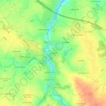
Name: Le Paradis topographic map, elevation, terrain.
Average elevation: 74 m
Minimum elevation: 49 m
Maximum elevation: 94 m
Other topographic maps
Click on a map to view its topography, its elevation and its terrain.
Villeneuve
France > Pays de la Loire > Vendée > Chauché
Villeneuve, Chauché, La Roche-sur-Yon, Vendée, Pays de la Loire, France métropolitaine, 85140, France
Average elevation: 81 m