
Thank you for supporting this site ❤️
Make a donation
Make a donation
Nicholson topographic map
Click on the map to display elevation.
Thank you for supporting this site ❤️
Make a donation
Make a donation
About this map
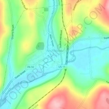
Name: Nicholson topographic map, elevation, terrain.
Average elevation: 273 m
Minimum elevation: 213 m
Maximum elevation: 379 m
Thank you for supporting this site ❤️
Make a donation
Make a donation
Other topographic maps
Click on a map to view its topography, its elevation and its terrain.
Lake Carey
United States > Pennsylvania > Wyoming County > Lemon Township > Lemon > Lake Carey
Average elevation: 323 m
Lake Sheridan Hill
United States > Pennsylvania > Wyoming County > Nicholson Township
Average elevation: 338 m
Blue Ridge Mountain
United States > Pennsylvania > Wyoming County > Meshoppen Township
Average elevation: 261 m
Thank you for supporting this site ❤️
Make a donation
Make a donation
Center Moreland
United States > Pennsylvania > Wyoming County > Northmoreland Township
Average elevation: 374 m
Bardwell
United States > Pennsylvania > Wyoming County > Tunkhannock Township
Average elevation: 297 m
Thank you for supporting this site ❤️
Make a donation
Make a donation