
Thank you for supporting this site ❤️
Make a donation
Make a donation
Madagascar topographic map
Click on the map to display elevation.
Thank you for supporting this site ❤️
Make a donation
Make a donation
About this map
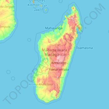
Name: Madagascar topographic map, elevation, terrain.
Location: Madagascar (-26.42496 38.94164 -11.42496 53.94164)
Average elevation: 127 m
Minimum elevation: -1 m
Maximum elevation: 2,770 m
Thank you for supporting this site ❤️
Make a donation
Make a donation
Other topographic maps
Click on a map to view its topography, its elevation and its terrain.