
Make a donation
Bologna topographic map
Click on the map to display elevation.
Make a donation
Bologna
Bologna is situated on the edge of the Po Plain at the foot of the Apennine Mountains, at the meeting of the Reno and Savena river valleys. As Bologna's two main watercourses flow directly to the sea, the town lies outside of the drainage basin of the River Po. The province of Bologna stretches from the western edge of the Po Plain on the border with Ferrara to the Tuscan-Emilian Apennines. The centre of the town is 54 metres (177 ft) above sea level (while elevation within the municipality ranges from 29 metres (95 ft) in the suburb of Corticella to 300 metres (980 ft) in Sabbiuno and the Colle della Guardia). The province of Bologna stretches from the Po Plain into the Apennines; the highest point in the province is the peak of Corno alle Scale (in Lizzano in Belvedere) at 1,945 metres (6,381 ft) above sea level.
Make a donation
About this map
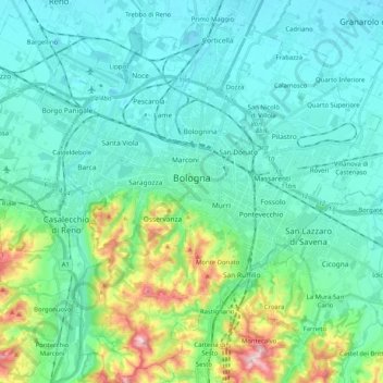
Name: Bologna topographic map, elevation, terrain.
Location: Bologna, Emilia-Romagna, Italy (44.42105 11.22962 44.55609 11.43361)
Average elevation: 91 m
Minimum elevation: 20 m
Maximum elevation: 391 m
Make a donation
Other topographic maps
Click on a map to view its topography, its elevation and its terrain.
La battaglia del Monte Castello
Italy > Emilia-Romagna > Bologna > Abetaia
Monte Castello is a hill located about 48 km (30 mi) north of Pistoia (Tuscany) and 60 km (37 mi) southwest of Bologna (Emilia-Romagna), via Località Abetaia (SP623), near Abetaia di Gaggio Montano, coordinates 44.221799, 10.954227, at 977 m (3,205 ft) altitude, in the Northern Apennines. on the border…
Average elevation: 845 m