
Gyumri topographic map
Interactive map
Click on the map to display elevation.
About this map
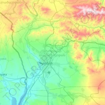
Name: Gyumri topographic map, elevation, terrain.
Location: Gyumri, Shirak Province, Armenia (40.68067 43.67376 40.96637 44.19324)
Average elevation: 1,845 m
Minimum elevation: 1,437 m
Maximum elevation: 2,985 m
Other topographic maps
Click on a map to view its topography, its elevation and its terrain.
Gyumri
Armenia > Shirak Province > Gyumri
Gyumri is 126 kilometres (78 miles) north of the capital Yerevan at the central part of the Shirak plateau. It has an approximate height of 1,550 metres (5,090 feet) above sea level, the high altitude line being 1,500 metres (4,900 feet). The Akhurian River passes through the western suburbs. The Shirak…
Average elevation: 1,535 m