
Sidi Belattar topographic map
Interactive map
Click on the map to display elevation.
About this map
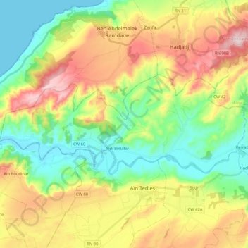
Name: Sidi Belattar topographic map, elevation, terrain.
Location: Sidi Belattar, daïra Aïn Tedles, Mostaganem, Algérie (36.00894 0.17393 36.07608 0.38232)
Average elevation: 169 m
Minimum elevation: 0 m
Maximum elevation: 436 m
Other topographic maps
Click on a map to view its topography, its elevation and its terrain.
Oued El Kheir
Algérie > Mostaganem > daïra Aïn Tedles
Oued El Kheir, daïra Aïn Tedles, Mostaganem, 27220, Algérie
Average elevation: 230 m
Aïn Tedles
Algérie > Mostaganem > daïra Aïn Tedles
Aïn Tedles, daïra Aïn Tedles, Mostaganem, 27001, Algérie
Average elevation: 196 m
Aïn Tedles
Algérie > Mostaganem > daïra Aïn Tedles
Aïn Tedles, daïra Aïn Tedles, Mostaganem, Algérie
Average elevation: 143 m