
Thank you for supporting this site ❤️
Make a donation
Make a donation
Sutton topographic map
Click on the map to display elevation.
Thank you for supporting this site ❤️
Make a donation
Make a donation
Sutton
Elevations in and around the town range from 115 metres (377 ft) AOD in Belmont to 23 metres (75 ft) in Sutton Common, at the start of the Pyl Brook stream.
Thank you for supporting this site ❤️
Make a donation
Make a donation
About this map
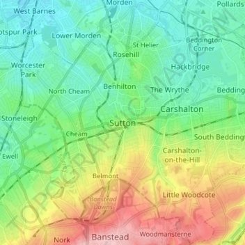
Name: Sutton topographic map, elevation, terrain.
Average elevation: 63 m
Minimum elevation: 14 m
Maximum elevation: 167 m
Thank you for supporting this site ❤️
Make a donation
Make a donation
Other topographic maps
Click on a map to view its topography, its elevation and its terrain.