
Thank you for supporting this site ❤️
Make a donation
Make a donation
Ramskapelle topographic map
Click on the map to display elevation.
Thank you for supporting this site ❤️
Make a donation
Make a donation
About this map
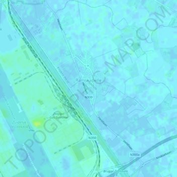
Name: Ramskapelle topographic map, elevation, terrain.
Location: Ramskapelle, Knokke-Heist, Brugge, West-Vlaanderen, België (51.29608 3.23581 51.32641 3.28233)
Average elevation: 2 m
Minimum elevation: -3 m
Maximum elevation: 11 m
Thank you for supporting this site ❤️
Make a donation
Make a donation
Other topographic maps
Click on a map to view its topography, its elevation and its terrain.