
Wil (SG) topographic map
Interactive map
Click on the map to display elevation.
About this map
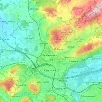
Name: Wil (SG) topographic map, elevation, terrain.
Location: Wil (SG), Wahlkreis Wil, St. Gallen, Schweiz (47.44623 9.00358 47.49579 9.09772)
Average elevation: 590 m
Minimum elevation: 498 m
Maximum elevation: 780 m
In Wil endet der 87 Kilometer lange Toggenburger Höhenweg, der in fünf Etappen von Wildhaus über Arvenbüel, Atzmännig und Mühlrüti nach Wil führt.
Other topographic maps
Click on a map to view its topography, its elevation and its terrain.
Hinterbach
Schweiz > St. Gallen > Wahlkreis Wil > Stolzenberg
Hinterbach, Oberuzwil, Stolzenberg, Riggenschwil, Wahlkreis Wil, St. Gallen, 9248, Schweiz
Average elevation: 617 m
Niederwil SG
Schweiz > St. Gallen > Wahlkreis Wil
Niederwil SG, Wahlkreis Wil, St. Gallen, 9203, Schweiz
Average elevation: 591 m