
Bois de l'Oratoire topographic map
Interactive map
Click on the map to display elevation.
About this map
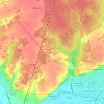
Name: Bois de l'Oratoire topographic map, elevation, terrain.
Average elevation: 121 m
Minimum elevation: 74 m
Maximum elevation: 145 m
Other topographic maps
Click on a map to view its topography, its elevation and its terrain.
Faubourg Saint-Lubin
France > Centre-Val de Loire > Loir-et-Cher > Vendôme
Faubourg Saint-Lubin, Vendôme-Quartiers Centre, Vendôme, Loir-et-Cher, Centre-Val de Loire, France métropolitaine, 41100, France
Average elevation: 104 m