
Niota topographic map
Interactive map
Click on the map to display elevation.
About this map
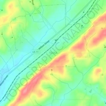
Name: Niota topographic map, elevation, terrain.
Location: Niota, McMinn County, Tennessee, 37926, United States (35.49842 -84.56946 35.52812 -84.53001)
Average elevation: 315 m
Minimum elevation: 280 m
Maximum elevation: 369 m
Other topographic maps
Click on a map to view its topography, its elevation and its terrain.
Prof Park
United States > Tennessee > McMinn County > Athens
Prof Park, Athens, McMinn County, East Tennessee, Tennessee, 37371, United States
Average elevation: 292 m
Athens
United States > Tennessee > McMinn County
Athens, McMinn County, Tennessee, United States
Average elevation: 291 m
Athens
United States > Tennessee > McMinn County > Athens
Athens, McMinn County, Tennessee, 37371, United States
Average elevation: 287 m
Etowah
United States > Tennessee > McMinn County > Etowah
Etowah, McMinn County, Tennessee, 37331, United States
Average elevation: 275 m
Calhoun
United States > Tennessee > McMinn County
Calhoun, McMinn County, East Tennessee, Tennessee, United States
Average elevation: 231 m