
Thank you for supporting this site ❤️
Make a donation
Make a donation
Plainview topographic map
Click on the map to display elevation.
Thank you for supporting this site ❤️
Make a donation
Make a donation
About this map
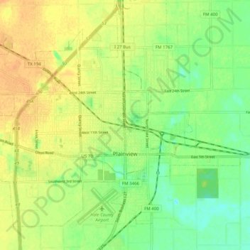
Name: Plainview topographic map, elevation, terrain.
Location: Plainview, Hale County, Texas, 79072, United States (34.15597 -101.76050 34.23244 -101.66115)
Average elevation: 1,029 m
Minimum elevation: 1,013 m
Maximum elevation: 1,041 m
Thank you for supporting this site ❤️
Make a donation
Make a donation
Other topographic maps
Click on a map to view its topography, its elevation and its terrain.
Abernathy
United States > Texas > Hale County
Abernathy (elevation 3,360 feet) is located at 33°49′56″N 101°50′35″W / 33.83222°N 101.84306°W / 33.83222; -101.84306 (33.8323038, –101.8429491). Most of the city is located in Hale County; roughly 25% of the city extends southward into Lubbock County.
Average elevation: 1,020 m