
Wittenbach topographic map
Interactive map
Click on the map to display elevation.
About this map
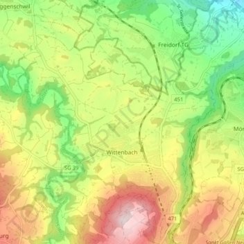
Name: Wittenbach topographic map, elevation, terrain.
Location: Wittenbach, Wahlkreis St. Gallen, St. Gallen, 9300, Schweiz (47.44225 9.35056 47.49566 9.41243)
Average elevation: 592 m
Minimum elevation: 415 m
Maximum elevation: 804 m
Other topographic maps
Click on a map to view its topography, its elevation and its terrain.
Sankt Gallen
Schweiz > St. Gallen > Wahlkreis St. Gallen
Sankt Gallen, Wahlkreis St. Gallen, St. Gallen, Schweiz
Average elevation: 741 m
Bernhardzell
Schweiz > St. Gallen > Wahlkreis St. Gallen
Bernhardzell, Waldkirch, Wahlkreis St. Gallen, St. Gallen, 9304, Schweiz
Average elevation: 629 m
Gossau (SG)
Schweiz > St. Gallen > Wahlkreis St. Gallen
Gossau (SG), Wahlkreis St. Gallen, St. Gallen, Schweiz
Average elevation: 667 m