
Make a donation
Villers-le-Sec topographic map
Click on the map to display elevation.
Make a donation
About this map
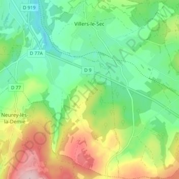
Name: Villers-le-Sec topographic map, elevation, terrain.
Average elevation: 308 m
Minimum elevation: 235 m
Maximum elevation: 437 m
Make a donation
Other topographic maps
Click on a map to view its topography, its elevation and its terrain.
Fougerolles
France > Bourgogne-Franche-Comté > Haute-Saône > Fougerolles-Saint-Valbert
Average elevation: 340 m
Athesans
France > Bourgogne-Franche-Comté > Haute-Saône > Athesans-Étroitefontaine
Average elevation: 300 m
Make a donation
Le Sabot
France > Bourgogne-Franche-Comté > Haute-Saône > Frotey-lès-Vesoul > Le Sabot
Average elevation: 257 m
Make a donation
Make a donation
Planche des Belles Filles
France > Bourgogne-Franche-Comté > Haute-Saône > Plancher-les-Mines
Average elevation: 860 m
Make a donation
Viaux les Champs
France > Bourgogne-Franche-Comté > Haute-Saône > Esmoulières
Average elevation: 572 m
Blanzey
France > Bourgogne-Franche-Comté > Haute-Saône > Fougerolles-Saint-Valbert
Average elevation: 389 m
Make a donation
Echevanne
France > Bourgogne-Franche-Comté > Haute-Saône > Velesmes-Échevanne
Average elevation: 225 m
Les Sept Fontaines
France > Bourgogne-Franche-Comté > Haute-Saône > La Vernotte
Average elevation: 231 m
Make a donation
Les Tournières
France > Bourgogne-Franche-Comté > Haute-Saône > Charmes-Saint-Valbert
Average elevation: 325 m
Nervezain
France > Bourgogne-Franche-Comté > Haute-Saône > Vauconcourt-Nervezain
Average elevation: 244 m
Maison du Bois
France > Bourgogne-Franche-Comté > Haute-Saône > Amblans-et-Velotte
Average elevation: 317 m
Make a donation
Broye-lès-Pesmes
France > Bourgogne-Franche-Comté > Haute-Saône > Broye-Aubigney-Montseugny
Average elevation: 193 m
Montelimard
France > Bourgogne-Franche-Comté > Haute-Saône > Dampierre-sur-Linotte > Les Grillardes
Average elevation: 330 m
Magny Maubert
France > Bourgogne-Franche-Comté > Haute-Saône > Servance-Miellin
Average elevation: 577 m
Broye-les-Loups
France > Bourgogne-Franche-Comté > Haute-Saône > Broye-les-Loups-et-Verfontaine
Average elevation: 234 m
Make a donation
Crevans
France > Bourgogne-Franche-Comté > Haute-Saône > Crevans-et-la-Chapelle-lès-Granges
Average elevation: 344 m
Les Forges
France > Bourgogne-Franche-Comté > Haute-Saône > Raddon-et-Chapendu
Average elevation: 421 m
Courbenans
France > Bourgogne-Franche-Comté > Haute-Saône > Vellechevreux-et-Courbenans
Average elevation: 376 m
Make a donation
Fort de Château-Lambert
France > Bourgogne-Franche-Comté > Haute-Saône > Haut-du-Them-Château-Lambert
Average elevation: 674 m
Les Breuchots
France > Bourgogne-Franche-Comté > Haute-Saône > Servance-Miellin
Average elevation: 564 m
Make a donation
Make a donation
They-en-Sorans
France > Bourgogne-Franche-Comté > Haute-Saône > Sorans-lès-Breurey
Average elevation: 258 m
La Fonderie
France > Bourgogne-Franche-Comté > Haute-Saône > Haut-du-Them-Château-Lambert
Average elevation: 796 m
Make a donation
Vellexon
France > Bourgogne-Franche-Comté > Haute-Saône > Vellexon-Queutrey-et-Vaudey
Average elevation: 217 m
Noroy-lès-Jussey
France > Bourgogne-Franche-Comté > Haute-Saône > Jussey > Noroy-lès-Jussey
Average elevation: 267 m
Make a donation
La Goutte
France > Bourgogne-Franche-Comté > Haute-Saône > Mailleroncourt-Charette
Average elevation: 279 m
Pré Boichey
France > Bourgogne-Franche-Comté > Haute-Saône > Servance-Miellin
Average elevation: 563 m
Make a donation
Make a donation
Champagney - Le Bas des Côtes
France > Bourgogne-Franche-Comté > Haute-Saône > Champagney
Average elevation: 392 m
La Bachetey
France > Bourgogne-Franche-Comté > Haute-Saône > Beulotte-Saint-Laurent > La Bachetey
Average elevation: 660 m
Les Bastiens
France > Bourgogne-Franche-Comté > Haute-Saône > Saint-Bresson > Les Bastiens
Average elevation: 543 m
Make a donation
Le Petit Fahys
France > Bourgogne-Franche-Comté > Haute-Saône > Fougerolles-Saint-Valbert
Average elevation: 367 m
Château de Fondremand
France > Bourgogne-Franche-Comté > Haute-Saône > Fondremand
Average elevation: 322 m
Make a donation
Le Pont Vautey
France > Bourgogne-Franche-Comté > Haute-Saône > Faucogney-et-la-Mer > Le Pont Vautey
Average elevation: 454 m
Le Voirmet
France > Bourgogne-Franche-Comté > Haute-Saône > Servance-Miellin > Miellin
Average elevation: 796 m
Le Grilloux
France > Bourgogne-Franche-Comté > Haute-Saône > Servance-Miellin > Le Grilloux
Average elevation: 587 m
La Clairegoutte
France > Bourgogne-Franche-Comté > Haute-Saône > Clairegoutte
Average elevation: 348 m
Make a donation
Servance
France > Bourgogne-Franche-Comté > Haute-Saône > Servance-Miellin > Servance
Average elevation: 527 m
Velesmes
France > Bourgogne-Franche-Comté > Haute-Saône > Velesmes-Échevanne > Velesmes
Average elevation: 222 m
Make a donation
La Goulotte
France > Bourgogne-Franche-Comté > Haute-Saône > Mélisey > La Goulotte
Average elevation: 349 m
Miserey
France > Bourgogne-Franche-Comté > Haute-Saône > Calmoutier > Miserey
Average elevation: 303 m
Les Évaudois
France > Bourgogne-Franche-Comté > Haute-Saône > Servance-Miellin > Les Évaudois
Average elevation: 549 m
Le Fahys
France > Bourgogne-Franche-Comté > Haute-Saône > Saint-Bresson > Le Fahys
Average elevation: 509 m
Make a donation
Montseugny
France > Bourgogne-Franche-Comté > Haute-Saône > Broye-Aubigney-Montseugny > Montseugny
Average elevation: 215 m
L'Enclose du Monthury
France > Bourgogne-Franche-Comté > Haute-Saône > Servance-Miellin
Average elevation: 576 m
Make a donation
Le Haut de la Côte
France > Bourgogne-Franche-Comté > Haute-Saône > Raddon-et-Chapendu
Average elevation: 418 m
Saint-Albin
France > Bourgogne-Franche-Comté > Haute-Saône > Scey-sur-Saône-et-Saint-Albin
Average elevation: 233 m
Make a donation