
Make a donation
Pavia topographic map
Click on the map to display elevation.
Make a donation
Pavia
From an elevation point of view, the city has various heights. The highest point is located in the area of the Visconti Castle, about 80 m (260 ft) above sea level, and then slowly declines. From an altitude of 80 m (260 ft), you pass to 77 m (253 ft) in about 500 m (550 yd; 1,600 ft). Downstream from Piazza Vittoria, where the cardo and decumanus of the Roman city crossed, the slope becomes more pronounced, up to just under 60 m (200 ft) above sea level near the Ponte Coperto.
Make a donation
About this map
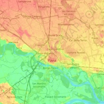
Name: Pavia topographic map, elevation, terrain.
Location: Pavia, Lombardy, 27100, Italy (45.15574 9.09038 45.23331 9.24055)
Average elevation: 74 m
Minimum elevation: 50 m
Maximum elevation: 93 m
Make a donation
Other topographic maps
Click on a map to view its topography, its elevation and its terrain.
Make a donation
Make a donation
Make a donation
Make a donation