
Dunston Heath topographic map
Interactive map
Click on the map to display elevation.
About this map
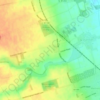
Name: Dunston Heath topographic map, elevation, terrain.
Average elevation: 30 m
Minimum elevation: 7 m
Maximum elevation: 52 m
Other topographic maps
Click on a map to view its topography, its elevation and its terrain.
Sleaford
United Kingdom > England > North Kesteven > Sleaford
Sleaford, Lincolnshire, East Midlands, England, NG34 7SX, United Kingdom
Average elevation: 21 m
Ashby de la Launde
United Kingdom > England > North Kesteven > Ashby de la Launde
Ashby de la Launde, Ashby de la Launde and Bloxholm, North Kesteven, Lincolnshire, East Midlands, England, LN4 3JG, United Kingdom
Average elevation: 30 m
Eagle Moor
United Kingdom > England > North Kesteven > Eagle > Eagle Moor
Eagle Moor, Eagle and Swinethorpe, Eagle, North Kesteven, Lincolnshire, East Midlands, England, LN6 9DP, United Kingdom
Average elevation: 20 m
Canwick
United Kingdom > England > North Kesteven > Canwick
Canwick, North Kesteven, Lincolnshire, East Midlands, England, LN4 2NY, United Kingdom
Average elevation: 34 m
Heckington
United Kingdom > England > North Kesteven > Heckington
Heckington, North Kesteven, Lincolnshire, East Midlands, England, NG34 9RF, United Kingdom
Average elevation: 8 m
North Rauceby
United Kingdom > England > North Kesteven
North Rauceby, North Kesteven, Lincolnshire, East Midlands, England, United Kingdom
Average elevation: 59 m
Greylees
United Kingdom > England > North Kesteven > Greylees
Greylees, North Kesteven, Lincolnshire, East Midlands, England, United Kingdom
Average elevation: 26 m
Temple Bruer
United Kingdom > England > North Kesteven > Temple Bruer
Temple Bruer, North Kesteven, Lincolnshire, East Midlands, England, LN5 0DG, United Kingdom
Average elevation: 58 m
Abbey Parks
United Kingdom > England > North Kesteven
Abbey Parks, North Kesteven, Lincolnshire, East Midlands, England, PE20 3QG, United Kingdom
Average elevation: 3 m
Dogdyke CP
United Kingdom > England > North Kesteven
Dogdyke CP, North Kesteven, Lincolnshire, East Midlands, England, United Kingdom
Average elevation: 3 m
Kirkby la Thorpe CP
United Kingdom > England > North Kesteven
Kirkby la Thorpe CP, North Kesteven, Lincolnshire, East Midlands, England, United Kingdom
Average elevation: 12 m
Witham St. Hughs CP
United Kingdom > England > North Kesteven
Witham St. Hughs CP, North Kesteven, Lincolnshire, East Midlands, England, United Kingdom
Average elevation: 17 m
Whisby Nature Park
United Kingdom > England > North Kesteven
Whisby Nature Park, Moor Lane, Thorpe on the Hill CP, North Kesteven, Lincolnshire, East Midlands, England, LN6 9BW, United Kingdom
Average elevation: 19 m
Cranwell Branch Line
United Kingdom > England > North Kesteven
Cranwell Branch Line, Drove Lane, Quarrington Hill, Sleaford CP, North Kesteven, Lincolnshire, East Midlands, England, NG34 8JQ, United Kingdom
Average elevation: 25 m
Skellingthorpe CP
United Kingdom > England > North Kesteven
Skellingthorpe CP, North Kesteven, Lincolnshire, East Midlands, England, United Kingdom
Average elevation: 11 m
River Slea
United Kingdom > England > North Kesteven
River Slea, North Kesteven, Lincolnshire, East Midlands, England, NG34 8PT, United Kingdom
Average elevation: 29 m