
Trillou topographic map
Interactive map
Click on the map to display elevation.
About this map
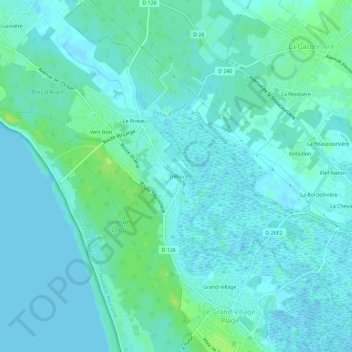
Name: Trillou topographic map, elevation, terrain.
Average elevation: 4 m
Minimum elevation: -1 m
Maximum elevation: 13 m
Other topographic maps
Click on a map to view its topography, its elevation and its terrain.
La Giraudière
France > Nouvelle-Aquitaine > Charente-Maritime > Le Grand-Village-Plage
La Giraudière, Le Grand-Village-Plage, Rochefort, Charente-Maritime, Nouvelle-Aquitaine, France métropolitaine, 17370, France
Average elevation: 4 m
Grand-Village
France > Nouvelle-Aquitaine > Charente-Maritime > Le Grand-Village-Plage
Grand-Village, Le Grand-Village-Plage, Rochefort, Charente-Maritime, Nouvelle-Aquitaine, France métropolitaine, 17370, France
Average elevation: 4 m
Petit-Village
France > Nouvelle-Aquitaine > Charente-Maritime > Le Grand-Village-Plage
Petit-Village, Le Grand-Village-Plage, Rochefort, Charente-Maritime, Nouvelle-Aquitaine, France métropolitaine, 17370, France
Average elevation: 4 m