
Thank you for supporting this site ❤️
Make a donation
Make a donation
Burr Ridge topographic map
Click on the map to display elevation.
Thank you for supporting this site ❤️
Make a donation
Make a donation
About this map
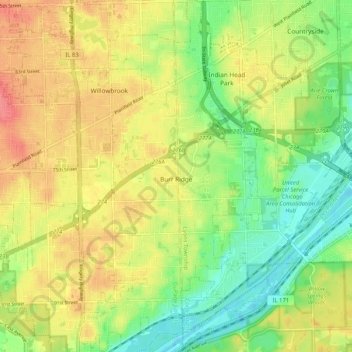
Name: Burr Ridge topographic map, elevation, terrain.
Location: Burr Ridge, DuPage County, Illinois, 65027, United States (41.71228 -87.94522 41.78957 -87.89267)
Average elevation: 209 m
Minimum elevation: 177 m
Maximum elevation: 242 m
Thank you for supporting this site ❤️
Make a donation
Make a donation
Other topographic maps
Click on a map to view its topography, its elevation and its terrain.
Downers Grove
United States > Illinois > DuPage County > Downers Grove > Downers Grove
Average elevation: 227 m