
Thank you for supporting this site ❤️
Make a donation
Make a donation
Greenwood topographic map
Click on the map to display elevation.
Thank you for supporting this site ❤️
Make a donation
Make a donation
About this map
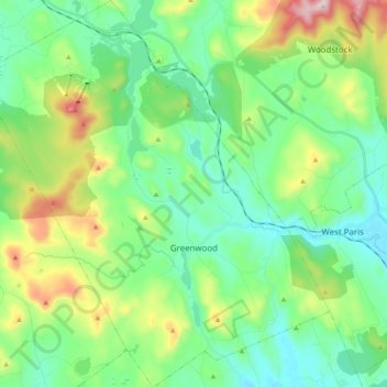
Name: Greenwood topographic map, elevation, terrain.
Location: Greenwood, Oxford County, Maine, 04255, United States (44.26671 -70.76275 44.40981 -70.58076)
Average elevation: 295 m
Minimum elevation: 132 m
Maximum elevation: 729 m
Thank you for supporting this site ❤️
Make a donation
Make a donation
Other topographic maps
Click on a map to view its topography, its elevation and its terrain.
Thank you for supporting this site ❤️
Make a donation
Make a donation
Thank you for supporting this site ❤️
Make a donation
Make a donation