
Stein an der Traun topographic map
Interactive map
Click on the map to display elevation.
About this map
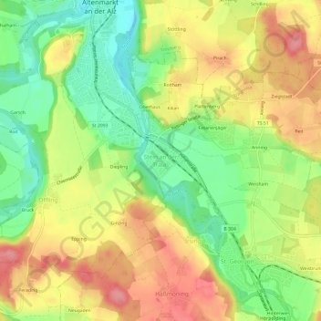
Name: Stein an der Traun topographic map, elevation, terrain.
Average elevation: 534 m
Minimum elevation: 486 m
Maximum elevation: 580 m
Other topographic maps
Click on a map to view its topography, its elevation and its terrain.
Oberhaus
Deutschland > Bayern > Landkreis Traunstein > Traunreut > Stein an der Traun
Oberhaus, Stein an der Traun, Traunreut, Landkreis Traunstein, Bayern, 83371, Deutschland
Average elevation: 530 m
St. Georgen
Deutschland > Bayern > Landkreis Traunstein > Traunreut
St. Georgen, Traunreut, Landkreis Traunstein, Bayern, 83368, Deutschland
Average elevation: 541 m