
Stratford-upon-Avon topographic map
Interactive map
Click on the map to display elevation.
About this map
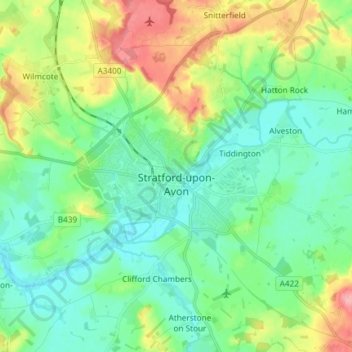
Name: Stratford-upon-Avon topographic map, elevation, terrain.
Average elevation: 61 m
Minimum elevation: 32 m
Maximum elevation: 129 m
Other topographic maps
Click on a map to view its topography, its elevation and its terrain.
Burton Dassett Hills Country Park
Vereinigtes Königreich > England > Warwickshire > Stratford-on-Avon > Northend > Burton Dassett CP
Burton Dassett Hills Country Park, Burton Dassett CP, Northend, Stratford-on-Avon, Warwickshire, England, Vereinigtes Königreich
Average elevation: 132 m