
Thank you for supporting this site ❤️
Make a donation
Make a donation
Lagar Velho topographic map
Click on the map to display elevation.
Thank you for supporting this site ❤️
Make a donation
Make a donation
About this map
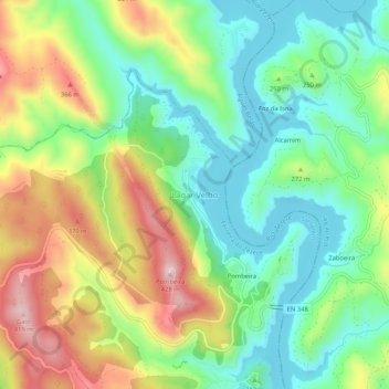
Name: Lagar Velho topographic map, elevation, terrain.
Location: Lagar Velho, Ferreira do Zêzere, Santarém, 2240, Portugal (39.68869 -8.26222 39.72869 -8.22222)
Average elevation: 223 m
Minimum elevation: 105 m
Maximum elevation: 416 m
Thank you for supporting this site ❤️
Make a donation
Make a donation
Other topographic maps
Click on a map to view its topography, its elevation and its terrain.
Paio Mendes
Portugal > Santarém > Ferreira do Zêzere > Nossa Senhora do Pranto
Average elevation: 294 m
Thank you for supporting this site ❤️
Make a donation
Make a donation