
La Grange topographic map
Interactive map
Click on the map to display elevation.
About this map
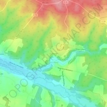
Name: La Grange topographic map, elevation, terrain.
Average elevation: 130 m
Minimum elevation: 82 m
Maximum elevation: 192 m
Other topographic maps
Click on a map to view its topography, its elevation and its terrain.
Chez le Bossu
France > Nouvelle-Aquitaine > Charente > Saint-Mary
Chez le Bossu, Saint-Mary, Confolens, Charente, Nouvelle-Aquitaine, France métropolitaine, 16260, France
Average elevation: 129 m
La Cour
France > Nouvelle-Aquitaine > Charente > Saint-Mary > La Cour
La Cour, Saint-Mary, Confolens, Charente, Nouvelle-Aquitaine, France métropolitaine, 16260, France
Average elevation: 109 m