
Thank you for supporting this site ❤️
Make a donation
Make a donation
Landen topographic map
Click on the map to display elevation.
Thank you for supporting this site ❤️
Make a donation
Make a donation
About this map
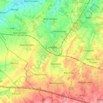
Name: Landen topographic map, elevation, terrain.
Location: Landen, Leuven, Flemish Brabant, Flanders, Belgium (50.70335 4.98392 50.79479 5.12144)
Average elevation: 85 m
Minimum elevation: 36 m
Maximum elevation: 140 m
Thank you for supporting this site ❤️
Make a donation
Make a donation
Other topographic maps
Click on a map to view its topography, its elevation and its terrain.
Doode Bemde
Belgium > Flemish Brabant > Leuven > Oud-Heverlee > Sint-Joris-Weert
Average elevation: 48 m