
Thank you for supporting this site ❤️
Make a donation
Make a donation
Forest Township topographic map
Click on the map to display elevation.
Thank you for supporting this site ❤️
Make a donation
Make a donation
About this map
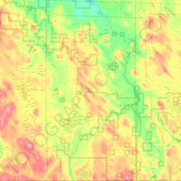
Name: Forest Township topographic map, elevation, terrain.
Average elevation: 254 m
Minimum elevation: 211 m
Maximum elevation: 304 m
Thank you for supporting this site ❤️
Make a donation
Make a donation
Other topographic maps
Click on a map to view its topography, its elevation and its terrain.
Mullet Lake Village Boating Access Site
United States > Michigan > Cheboygan County > Inverness Township
Average elevation: 185 m