
Póvoa da Isenta topographic map
Interactive map
Click on the map to display elevation.
About this map
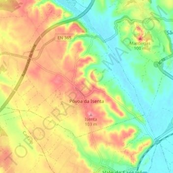
Name: Póvoa da Isenta topographic map, elevation, terrain.
Location: Póvoa da Isenta, Santarém, Portugal (39.20312 -8.79080 39.23547 -8.72041)
Average elevation: 56 m
Minimum elevation: 1 m
Maximum elevation: 103 m
Other topographic maps
Click on a map to view its topography, its elevation and its terrain.
Vale de Santarém
Portugal > Santarém > Santarém
Vale de Santarém, Santarém, 2005-039, Portugal
Average elevation: 45 m
São Vicente do Paul
Portugal > Santarém > Santarém
São Vicente do Paul, Santarém, 2000-680, Portugal
Average elevation: 42 m