
Loch Toll an Lochain topographic map
Interactive map
Click on the map to display elevation.
About this map
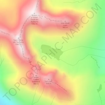
Name: Loch Toll an Lochain topographic map, elevation, terrain.
Location: Loch Toll an Lochain, Highland, Scotland, United Kingdom (57.79498 -5.24874 57.79914 -5.23755)
Average elevation: 637 m
Minimum elevation: 118 m
Maximum elevation: 1,041 m
Other topographic maps
Click on a map to view its topography, its elevation and its terrain.
Scottish Highlands
United Kingdom > Scotland > Highland
Scottish Highlands, Highland, Scotland, United Kingdom
Average elevation: 907 m
Eilean Mhic Dhòmhnuill Dhuibh
United Kingdom > Scotland > Highland
Eilean Mhic Dhòmhnuill Dhuibh, Highland, Scotland, United Kingdom
Average elevation: 113 m
Fodderty
United Kingdom > Scotland > Highland
Fodderty, Highland, Scotland, IV14 9AF, United Kingdom
Average elevation: 129 m
Lewiston
United Kingdom > Scotland > Highland
Lewiston, Highland, Scotland, IV63 6UD, United Kingdom
Average elevation: 127 m
Kingussie
United Kingdom > Scotland > Highland
Kingussie, Highland, Scotland, PH21 1LQ, United Kingdom
Average elevation: 338 m
Tornagrain
United Kingdom > Scotland > Highland > Inverness
Tornagrain, Inverness, Highland, Scotland, IV2 7JJ, United Kingdom
Average elevation: 46 m
Newtonmore
United Kingdom > Scotland > Highland
Newtonmore, Highland, Scotland, PH20 1DN, United Kingdom
Average elevation: 283 m
Tornagrain
United Kingdom > Scotland > Highland
Tornagrain, Highland, Scotland, IV2 8AL, United Kingdom
Average elevation: 51 m
Loch Ness
United Kingdom > Scotland > Highland > Dores
Loch Ness, Dores, Highland, Scotland, PH32 4BN, United Kingdom
Average elevation: 340 m
Ullapool
United Kingdom > Scotland > Highland
Ullapool, Highland, Scotland, IV26 2XE, United Kingdom
Average elevation: 150 m
Cairn Gorm
United Kingdom > Scotland > Highland
Cairn Gorm, Highland, Scotland, PH22 1RB, United Kingdom
Average elevation: 989 m
Buachaille Etive Mor
United Kingdom > Scotland > Highland
Buachaille Etive Mor, Highland, Scotland, United Kingdom
Average elevation: 566 m
Struy
United Kingdom > Scotland > Highland
Struy, Highland, Scotland, IV4 7JS, United Kingdom
Average elevation: 164 m
Stac Pollaidh (East Summit)
United Kingdom > Scotland > Highland
Stac Pollaidh (East Summit), Highland, Scotland, IV26 2XY, United Kingdom
Average elevation: 214 m
Tomnacross
United Kingdom > Scotland > Highland > Kiltarlity
Tomnacross, Kiltarlity, Highland, Scotland, IV4 7HW, United Kingdom
Average elevation: 87 m
Carbost
United Kingdom > Scotland > Highland
Carbost, Highland, Scotland, IV47 8SS, United Kingdom
Average elevation: 110 m
Ben Nevis
United Kingdom > Scotland > Highland
Ben Nevis, Highland, Scotland, United Kingdom
Average elevation: 912 m
Craigton
United Kingdom > Scotland > Highland > North Kessock
Craigton, North Kessock, Highland, Scotland, IV1 3YG, United Kingdom
Average elevation: 30 m
Lairg Muir
United Kingdom > Scotland > Highland > Lairg
Lairg Muir, Lairg, Highland, Scotland, IV27 4ED, United Kingdom
Average elevation: 138 m
Glen Hill
United Kingdom > Scotland > Highland
Glen Hill, Highland, Scotland, KW11 6UE, United Kingdom
Average elevation: 205 m
Dunvegan
United Kingdom > Scotland > Highland
Dunvegan, Highland, Scotland, IV55 8WB, United Kingdom
Average elevation: 41 m
Nairn
United Kingdom > Scotland > Highland
Nairn, Highland, Scotland, IV12 4BW, United Kingdom
Average elevation: 18 m
Gairloch
United Kingdom > Scotland > Highland > Gairloch
Gairloch, Highland, Scotland, IV21 2DP, United Kingdom
Average elevation: 83 m
Alvie
United Kingdom > Scotland > Highland > Alvie
Alvie, Highland, Scotland, PH22 1QB, United Kingdom
Average elevation: 285 m
Torlundy
United Kingdom > Scotland > Highland > Torlundy
Torlundy, Highland, Scotland, PH33 6SS, United Kingdom
Average elevation: 90 m
Salen
United Kingdom > Scotland > Highland > Salen
Salen, Highland, Scotland, PH36 4JN, United Kingdom
Average elevation: 83 m
Pinnacle Ridge
United Kingdom > Scotland > Highland
Pinnacle Ridge, Highland, Scotland, IV47 8SW, United Kingdom
Average elevation: 472 m
Dulnain Bridge
United Kingdom > Scotland > Highland > Dulnain Bridge
Dulnain Bridge, Highland, Scotland, PH26 3LT, United Kingdom
Average elevation: 254 m
Kyleakin
United Kingdom > Scotland > Highland > Kyleakin
Kyleakin, Highland, Scotland, IV41 8PH, United Kingdom
Average elevation: 48 m
Applecross
United Kingdom > Scotland > Highland
Applecross, Highland, Scotland, United Kingdom
Average elevation: 149 m
Drumnadrochit
United Kingdom > Scotland > Highland
Drumnadrochit, Highland, Scotland, IV63 6TX, United Kingdom
Average elevation: 159 m
Inverness
United Kingdom > Scotland > Highland
Inverness, Highland, Scotland, IV1 1AN, United Kingdom
Average elevation: 163 m
Portree
United Kingdom > Scotland > Highland
Portree, Highland, Scotland, IV51 9EH, United Kingdom
Average elevation: 121 m
Mallaig
United Kingdom > Scotland > Highland
Mallaig, Highland, Scotland, PH41 4QA, United Kingdom
Average elevation: 25 m
Attadale
United Kingdom > Scotland > Highland
Attadale, Highland, Scotland, IV54 8WZ, United Kingdom
Average elevation: 122 m
Kentallen
United Kingdom > Scotland > Highland
Kentallen, Highland, Scotland, PA38 4BZ, United Kingdom
Average elevation: 204 m
Dingwall
United Kingdom > Scotland > Highland
Dingwall, Highland, Scotland, IV15 9RU, United Kingdom
Average elevation: 94 m
Broadford
United Kingdom > Scotland > Highland
Broadford, Highland, Scotland, IV49 9AD, United Kingdom
Average elevation: 34 m
John o' Groats
United Kingdom > Scotland > Highland
John o' Groats, Highland, Scotland, KW1 4YR, United Kingdom
Average elevation: 30 m
Grampian Mountains
United Kingdom > Scotland > Highland
Grampian Mountains, Highland, Scotland, United Kingdom
Average elevation: 775 m
Inveralligin
United Kingdom > Scotland > Highland
Inveralligin, Highland, Scotland, IV22 2HB, United Kingdom
Average elevation: 121 m
Torridon
United Kingdom > Scotland > Highland
Torridon, Highland, Scotland, IV22 2EZ, United Kingdom
Average elevation: 236 m