
Lac de Chambon topographic map
Interactive map
Click on the map to display elevation.
About this map
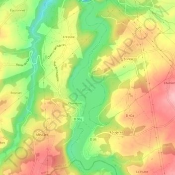
Name: Lac de Chambon topographic map, elevation, terrain.
Average elevation: 237 m
Minimum elevation: 156 m
Maximum elevation: 306 m
Établi à 203,7 m d'altitude, le lac a une longueur de 16 km, une largeur de 751 m, une superficie de 312 ha et un volume d'eau de 57,2 millions de m3.
Other topographic maps
Click on a map to view its topography, its elevation and its terrain.
La Jarrige
France > Centre-Val de Loire > Indre > Cuzion
La Jarrige, Cuzion, Châteauroux, Indre, Centre-Val de Loire, France métropolitaine, 36190, France
Average elevation: 236 m