
Boughezoul topographic map
Interactive map
Click on the map to display elevation.
About this map
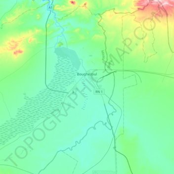
Name: Boughezoul topographic map, elevation, terrain.
Location: Boughezoul, Daïra Chahbounia, Médéa, Algérie (35.53183 2.62908 35.82922 2.90450)
Average elevation: 673 m
Minimum elevation: 607 m
Maximum elevation: 980 m
La commune de Boughezoul est située dans la région des hauts-plateaux à plus de 600 mètres d'altitude. Une grande partie de son territoire est occupée par le barrage qui porte son nom, inauguré le 30 novembre 1933 dans lequel se jette l'oued Nahr-Ouassel et qui se prolonge dans l'Oued Chlef.
Other topographic maps
Click on a map to view its topography, its elevation and its terrain.
Bouaiche
Algérie > Médéa > Daïra Chahbounia
Bouaiche, Daïra Chahbounia, Médéa, Algérie
Average elevation: 779 m