
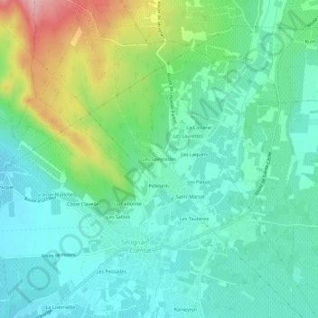
Les Soleyrades topographic map
Interactive map
Click on the map to display elevation.
About this map
Name: Les Soleyrades topographic map, elevation, terrain.
Average elevation: 102 m
Minimum elevation: 55 m
Maximum elevation: 226 m
Other topographic maps
Click on a map to view its topography, its elevation and its terrain.
Les Sables
France > Provence-Alpes-Côte d'Azur > Vaucluse > Sérignan-du-Comtat
Les Sables, Sérignan-du-Comtat, Carpentras, Vaucluse, Provence-Alpes-Côte d'Azur, France métropolitaine, 84830, France
Average elevation: 86 m
La Paillonne
France > Provence-Alpes-Côte d'Azur > Vaucluse > Sérignan-du-Comtat
La Paillonne, Sérignan-du-Comtat, Carpentras, Vaucluse, Provence-Alpes-Côte d'Azur, France métropolitaine, 84830, France
Average elevation: 90 m