
Make a donation
Smeermaas topographic map
Click on the map to display elevation.
Make a donation
About this map
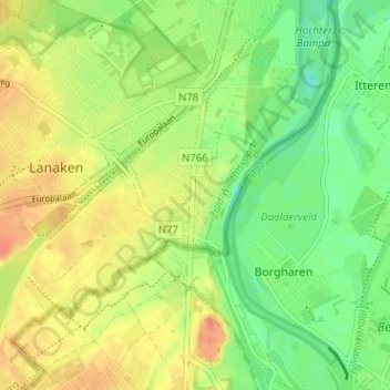
Name: Smeermaas topographic map, elevation, terrain.
Location: Smeermaas, Lanaken, Tongeren, Limburg, 3620, België (50.86644 5.65396 50.90644 5.69396)
Average elevation: 53 m
Minimum elevation: 29 m
Maximum elevation: 79 m
Make a donation
Other topographic maps
Click on a map to view its topography, its elevation and its terrain.
Rekem
België > Limburg > Tongeren > Lanaken
Rekem bevindt zich in de Maasvallei, op ongeveer 42 meter hoogte. Naar het westen toe gaat het over in het Kempens Plateau, dat via een steilrand oprijst en hier hoogten tot 92 meter bereikt. Op deze overgang bevonden zich het kinderopvangcentrum Molenberg en het sanatorium Onze-Lieve-Vrouwpreventorium Ter…
Average elevation: 47 m
Neerharen
België > Limburg > Tongeren > Lanaken
Neerharen ligt in de Maasvallei op een hoogte van ongeveer 45 meter, doch is van de Maas gescheiden door de Zuid-Willemsvaart. In de Maasuiterwaard ligt het natuurgebied Hochter Bampd. In het westen, aan de voet van de steilrand naar het Kempens Plateau, vindt men het natuurgebied Neerharerheide, een gebied…
Average elevation: 47 m
Veldwezelt
België > Limburg > Tongeren > Lanaken
Veldwezelt is gelegen in Droog-Haspengouw, op een hoogte van ongeveer 75 meter. De licht glooiende bodem bestaat uit löss. Het grondgebied wordt ten noorden en ten oosten van het dorp doorsneden door het Albertkanaal, waardoor een smalle strook min of meer geïsoleerd van het dorp is komen te liggen,…
Average elevation: 79 m
Make a donation