
Thank you for supporting this site ❤️
Make a donation
Make a donation
Tatysh topographic map
Click on the map to display elevation.
Thank you for supporting this site ❤️
Make a donation
Make a donation
About this map
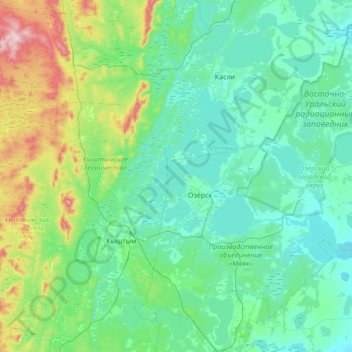
Name: Tatysh topographic map, elevation, terrain.
Location: Tatysh, Chelyabinsk Oblast, Ural Federal District, Russia (55.58674 60.57100 55.97389 61.08553)
Average elevation: 286 m
Minimum elevation: 213 m
Maximum elevation: 642 m
Thank you for supporting this site ❤️
Make a donation
Make a donation
Other topographic maps
Click on a map to view its topography, its elevation and its terrain.
Tyulyuk River
Russia > Chelyabinsk Oblast > Katav-Ivanovsky District > Tyulyuk
Average elevation: 675 m
Thank you for supporting this site ❤️
Make a donation
Make a donation
Thank you for supporting this site ❤️
Make a donation
Make a donation
Thank you for supporting this site ❤️
Make a donation
Make a donation