
Houx topographic map
Interactive map
Click on the map to display elevation.
About this map
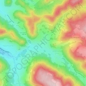
Name: Houx topographic map, elevation, terrain.
Average elevation: 550 m
Minimum elevation: 416 m
Maximum elevation: 716 m
Other topographic maps
Click on a map to view its topography, its elevation and its terrain.
Hérigoutte
France > Grand Est > Vosges > Laveline-du-Houx > Hérigoutte
Hérigoutte, Laveline-du-Houx, Épinal, Vosges, Grand Est, France métropolitaine, 88640, France
Average elevation: 606 m