
Jungfrau topographic map
Interactive map
Click on the map to display elevation.
About this map
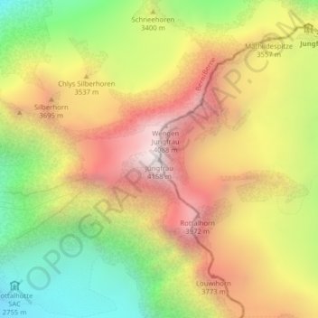
Name: Jungfrau topographic map, elevation, terrain.
Average elevation: 3,401 m
Minimum elevation: 2,638 m
Maximum elevation: 4,128 m
La Jungfrau (/ˈjʊŋfʁaʊ̯/) est un sommet individualisé des Alpes situé en Suisse dans le massif des Alpes bernoises. Il culmine à 4 158 mètres d'altitude.