
Thank you for supporting this site ❤️
Make a donation
Make a donation
Corbion topographic map
Click on the map to display elevation.
Thank you for supporting this site ❤️
Make a donation
Make a donation
About this map
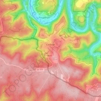
Name: Corbion topographic map, elevation, terrain.
Average elevation: 344 m
Minimum elevation: 190 m
Maximum elevation: 443 m
Thank you for supporting this site ❤️
Make a donation
Make a donation
Other topographic maps
Click on a map to view its topography, its elevation and its terrain.
Bouillon
Belgique > Luxembourg > Neufchâteau > Bouillon
Entourée de forêts, la ville s’étend dans et autour d’un méandre accentué de la Semois, un affluent de la Meuse. L'altitude y est d'environ 220 mètres. Elle est desservie par la route nationale 83 menant à Arlon, route qui borde la ville à l’est et qui se confond sur le territoire communal avec…
Average elevation: 338 m
Thank you for supporting this site ❤️
Make a donation
Make a donation
Le Tombeau du Géant
Belgique > Luxembourg > Neufchâteau > Bouillon > Botassart
Average elevation: 300 m