Geolocate

East Tennessee topographic map

Interactive map

Click on the map to display elevation.

East Tennessee

The Blue Ridge section comprises the western section of the Blue Ridge Province, the crests of which form most of the Tennessee-North Carolina border. At an average elevation of 5,000 feet (1,500 m) above sea level, this physiographic province contains the highest elevations in the state. The Blue Ridge region is subdivided into several subranges—the Iron Mountains, Unaka Range, and Bald Mountains in the north; the Great Smoky Mountains in the center; and the Unicoi Mountains, Little Frog Mountain, and Big Frog Mountain areas in the south. Kuwohi, at 6,643 feet (2,025 m), is the state's highest point and is located in the Great Smoky Mountains along the Tennessee-North Carolina border. Most of the Blue Ridge section is heavily forested and protected by various state and federal entities, the largest of which include the Great Smoky Mountains National Park and the Cherokee National Forest. The Appalachian Trail enters Tennessee in the Great Smoky Mountains and roughly follows the border with North Carolina most of the distance to near the Roan Mountain, where it shifts entirely into Tennessee.

Wikipedia (CC-BY-SA 3.0)

About this map

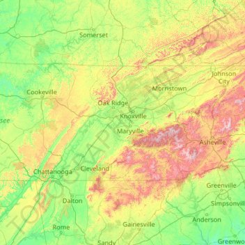
Name: East Tennessee topographic map, elevation, terrain.

Location: East Tennessee, Tennessee, United States (34.98294 -85.87303 36.61621 -81.64722)

Average elevation: 435 m

Minimum elevation: 123 m

Maximum elevation: 1,983 m

Other topographic maps

Click on a map to view its topography, its elevation and its terrain.

West Oneida

United States > Tennessee > Scott County > Oneida

Average elevation: 453 m

Hickory Hills

United States > Tennessee > Bradley County

Average elevation: 257 m

Beulah

United States > Tennessee > Union County

Average elevation: 336 m

Hedgemoor

United States > Tennessee > Shelby County > Memphis

Average elevation: 92 m

Walden Ridge

United States > Tennessee > Campbell County

Average elevation: 401 m

Cosby

United States > Tennessee > Cocke County

Average elevation: 483 m

Hancock

United States > Tennessee > Henry County > Paris

Average elevation: 146 m

Beaman Park

United States > Tennessee > Davidson County > Nashville > West

Average elevation: 228 m

Happy Valley

United States > Tennessee > Blount County

Average elevation: 473 m

McKinnon

United States > Tennessee > Houston County

Average elevation: 144 m

Climer

United States > Tennessee > Bradley County

Average elevation: 255 m

Bull Run

United States > Tennessee > Anderson County

Average elevation: 300 m

Hambright

United States > Tennessee > Polk County

Average elevation: 351 m

Eureka

United States > Tennessee > Bradley County

Average elevation: 237 m

Kenmark Hills

United States > Tennessee > Blount County

Average elevation: 325 m

Piney Grove

United States > Tennessee > Carter County

Average elevation: 828 m

Hillsdale

United States > Tennessee > Blount County > Maryville

Average elevation: 293 m

Tiger Valley

United States > Tennessee > Carter County

Average elevation: 747 m

Luskville

United States > Tennessee > McMinn County

Average elevation: 248 m

Chilhowee

United States > Tennessee > Blount County

Average elevation: 358 m

Newtown

United States > Tennessee > Scott County > Huntsville

Average elevation: 436 m

Douglas Dam

United States > Tennessee > Sevier County > Sevierville

The Douglas Project required the construction of ten smaller, earthen saddle dams to fill in gaps along the adjacent ridgeline and permit a higher water elevation than would otherwise be possible. Most of these saddle dams are located in the hills southeast of the main dam. One protects downtown Dandridge,…

Average elevation: 312 m

Oak Grove

United States > Tennessee > Monroe County

Average elevation: 290 m

Dante

United States > Tennessee > Knox County > Knoxville

Average elevation: 332 m

Peak

United States > Tennessee > Anderson County

Average elevation: 296 m

Granville

United States > Tennessee > Jackson County

Average elevation: 186 m

Morris Chapel

United States > Tennessee > Hardin County

Average elevation: 131 m

Pine Grove

United States > Tennessee > Loudon County

Average elevation: 289 m

Butler

United States > Tennessee > Johnson County

Average elevation: 671 m

Leeville

United States > Tennessee > Wilson County

Average elevation: 186 m

Cherry Creek

United States > Tennessee > White County

Average elevation: 345 m

Old Chilhowee

United States > Tennessee > Blount County

Average elevation: 399 m

Bemis

United States > Tennessee > Madison County > Jackson

Average elevation: 115 m

Peters Mill

United States > Tennessee > Knox County

Average elevation: 280 m

Kellys Island

United States > Tennessee > Decatur County

Average elevation: 179 m

Southport

United States > Tennessee > Maury County

Average elevation: 268 m

Douglas

United States > Tennessee > Williamson County

Average elevation: 221 m

Buntyn

United States > Tennessee > Shelby County > Memphis

Average elevation: 94 m

Haletown

United States > Tennessee > Marion County

Average elevation: 286 m

Cave Creek

United States > Tennessee > Roane County

Average elevation: 308 m

Darkey Springs

United States > Tennessee > White County

Average elevation: 298 m

Bellshire

United States > Tennessee > Davidson County > Nashville

Average elevation: 186 m

Bellshire

United States > Tennessee > Davidson County > Nashville

Average elevation: 186 m

Gladeville

United States > Tennessee > Wilson County

Average elevation: 186 m

Oak Grove

United States > Tennessee > Carter County

Average elevation: 536 m

Flag Pond

United States > Tennessee > Unicoi County

Average elevation: 846 m

Morgan Springs

United States > Tennessee > Rhea County

Average elevation: 589 m

Bybee

United States > Tennessee > Cocke County

Average elevation: 349 m

Lott Landing

United States > Tennessee > Hardin County

Average elevation: 124 m